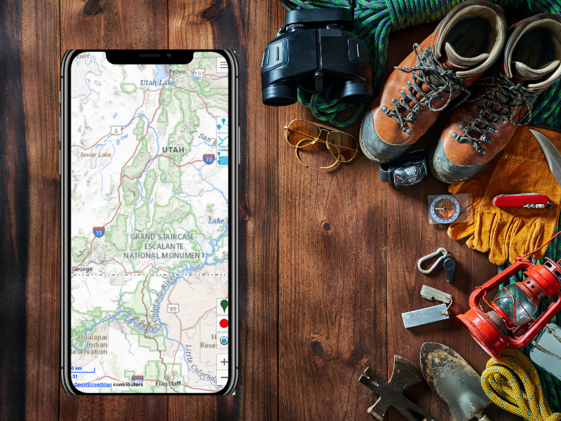
Offline Adventure Maps

The ultimate iPhone app for intuitive planning, confident exploring, and easy sharing of your outdoor adventures!

Our Key Advantages

HikingLogger-Planning

Intuitive Planning

We've designed hiking logger so you can plan your entire adventure ahead of time, entirely on your iPhone. There are also rich logging features, so when you're out exploring, you can record your path and add notes or photos along the route for future planning.

Confident Exploring

Hiking logger is built to guide you safely no matter how deep into the wilderness you want to venture. The offline maps are always available even in airplane mode so you can explore without straining your phone's battery.

Easy Route Sharing

Hiking logger lets you easily share your route in a variety of universal formats that can be used across a variety of navigation apps and devices. You can even publish detailed maps ready for physical printing.

“I used Hiking Logger on my last trip to Zion National Park, it gave me peace of mind while exploring the canyon.”

Tom H.

Our Vision for Hiking Logger

Create the best offline mapping app for the iPhone

Hiking Logger started off as a passion project by developers at our company that loved hiking and the great outdoors. It was soon discovered by hardcore hiking clubs who loved its rich and detailed maps and the offline functionality. It was these hiking groups that helped guide the development of Hiking Logger and continue to guide us in our development of what we hope to one day be the best offline map app for the iPhone.

QUESTIONS?

Whether you’re curious about features, ran into an issue, or have a suggestion, we’re here to answer any questions.

Intuitive Planning - A Closer Look

Intuitive planning is supported by three key features to make it a breeze to plan your journey entirely on your phone or prepare a route for sharing with larger groups. 

  • Route Tracing – use the point to point route creation by inserting waypoints to form your path or simply drag your finger along the approximate path you want to take, Hiking Logger will make the path for you. You can also use the magnet icon to ensure that your selection adjusts to match the closest navigable path. You can then review the distance, the difficulty based on elevation gain and try different alternatives. Save the route once satisfied and you’ll be able to follow it once you hit the trail. 
  • Detailed Recording – when exploring new trails for group hikes or your own future returns, you can turn on recording and automatically track time, distance, altitude and elevation gain. You can also add vasts amount of helpful info such as images, videos, and audio notes along important waypoints. 
  • Import Popular Hikes – hiking logger supports all major navigation tracking files such as GPX, KML, and KMZ. You can use our resource center to browse the most popular tracks in your location. 
HikingLogger-Planning

Confident Exploring - A Closer Look

When it comes to exploring, helping you feel safe and confident is our biggest concern when designing hiking logger. We’ve added the following features to make that a reality: 

  • Detailed Offline Maps – download maps before your journey and explore wilderness without having to waste your battery or having to rely on internet connection. You can use your maps much longer while in airplane mode and you can reach trails where internet is not available.
  • Off-Route Notification – adjustable text size lets you easily read the maps as you follow a pre-loaded track or explore new trails. Turn on off-route notifications and you’ll get an audio notification when you stray off the path. 
  • SOS Alerts – let you quickly notify your emergency contacts and send them an update with your location and condition if you face a challenge where you need a helping hand. 

Easy Route Sharing - A Closer Look

Whether it’s sending your previous hike to a select group of hikers or sharing your adventure to a wider public, we make it easy to help spread the joy of hiking: 

  • One Tap Sharing – after planning and creating a route in detail you can share it in any popular navigation file format with a friend or group of friends, or upload it to our public database of hikes enriched with all your waypoint information.
  • Create Professional Relief Maps – our advanced features let you create advanced navigation tools such as digital elevation models (DEM) relief maps. 
  • Print-Ready Maps – create images of maps with waypoints and detailed topography information. Print the maps out or post them on your hiking group website or social media page and let fellow hikers get a good idea about your trail with a single glance.